Fine Yatra

Fine Yatra an on line Indian Travel agency catering to Tours in India.

International Package

We are managing the LTC tour all across India and South East Asia like Singapore, Malaysia, Thailand, Dubai, Hongkong etc since last 6 years.

Domestic Package

We are a business partner, a friend, a community resource.

Hotel Bookings

Chennais's Best Tour operator of the year.

Car Bookings

Branches Throughout South India

Friday 13 February 2015

Place to visit

Shillong

Shillong (English pronunciation: Khasi: Shillong) is the capital and Hill station of Meghalaya, one of the smallest states in India. It is the headquarters of the East Khasi Hills district and is situated at an average altitude of 4,908 feet (1,496 m) above sea level, with the highest point being Shillong Peak at 6,449 feet (1,966 m). Shillong is the 330th most populous city in India with population of 143,007 according to the 2011 census. It is said that the rolling hills around the town reminded the European settlers of Scotland. Hence, Shillong is known as "Scotland of the East". The population density of the state of Meghalaya in the 2000s decade is 342 people per sq mile.It has steadily grown in size and significance since it was made the civil station of the Khasi and Jaintia Hills in 1864 by the British. In 1874, on the formation of Assam as a Chief Commissioner's Province, it was chosen as the headquarters of the new administration because of its convenient location between the Brahmaputra and Surma valleys and more so because the climate of Shillong was much cooler than tropical India. Shillong remained the capital of undivided Assam until the creation of the new state of Meghalaya on 21 January 1972, when Shillong became the capital of Meghalaya and Assam moved its capital to Dispur in Guwahati.


Places of interest


Elephant Falls: 12 km on the outskirts of the city, the mountain stream descends through two successive falls set in dells of fern covered rocks.Lady 


Hydari Park: The park stretches over a kilometre and has an adjacent mini zoo.


Wards Lake: Known locally as Nan-Polok. Its an artificial lake with garden and boating facilities.


Shillong Golf Course: Shillong has one of the largest golf courses (the world's wettest) in Asia: Gleneagles of the East. It enjoys the rare distinction of being one of the few natural golf courses in

Asia. Not only is the Shillong Golf Course scenic and enjoyable, it is also challenging. A group of British civil service officers introduced golf to Shillong in 1898 by constructing a nine-hole course. The present 18-hole course was inaugurated in 1924. The course is set in a valley covered with pine and rhododendron trees. The tight fairways, carpeted with a local grass which hardens the soil, are difficult to negotiate. The number of out-of-bounds streams that criss-cross every fairway makes it all the more trying. Obstructions come in the form of bunkers, trees and rain. The longest hole is the 6th, which is a gruelling 594 yards. Shillong Golf Course is considered to be the "Glen Eagle of the East" at the United States Golf Association Museum. It was set in a valley at an altitude of 5200 ft in 1898 as a nine-hole course and later converted into an 18-hole course in 1924 by Captain Jackson and C. K. Rhodes.

Motphran: The “Stone of France” which is locally known as "Motphran" was erected in memory of the 26th Khasi Labour Corps who served under the British in France during World War I. It bears the words of the famous Latin poet Horace "Dulce et decorum est pro patria mori" which can be roughly translated as "It is sweet and fitting to die for one's country".

Shillong Peak: A picnic spot, 10 km from the city, 1965 m above sea level, offers a panoramic view of the scenic countryside and is the highest point in the state. Obeisance is paid to U Shulong at the sanctum sanctorum at the peak's summit every springtime, by the religious priest of Mylliem State.Capt. 


Williamson Sangma State Museum: For those interested in ethnic tribal culture and tradition this

government museum offers insights to the lifestyle of the people. This museum is in the State Central Library complex where monuments for the great patriots of the state were erected besides the statue of Smt. Indira Gandhi and Netaji Subhash Chandra Bose.

Don Bosco Centre for Indigenous Cultures: The Don Bosco Museum is part of DBCIC (Don Bosco Centre for Indigenous


Cultures). DBCIC comprises research on cultures, publications, training, animation programmes and the museum, which is a place of knowledge-sharing on the cultures of the northeast in particular, and
of culture in general. DBCIC with its Don Bosco Museum is situated at Mawlai, Shillong.


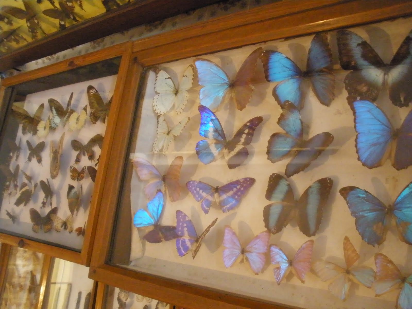
Entomological Museum (Butterfly Museum): A privately owned museum of M/s Wankhar, Riatsamthiah, Shillong about 2 km from Police Bazar is the only known museum in India devoted to moths and butterflies.Air Force Museum at Upper ShillongForest Museum in Lady Hydari ParkRhino Heritage Museum at ShillongZoological Museum in Risa ColonyAnthropological museum at MawbleiBotanical Museum at 4th FurlongArunachal Museum at the Cantonment Area


Chrysalis the Gallery: This art gallery is on the second floor of Salonsar Mansion at Police Bazaar, the commercial hub of Shillong. Chrysalis has flexible spacing to display paintings (canvases), sculpture, photography and handicrafts. Run by a local artist, Jaya Kalra, the gallery caters to exhibitions of artists and artisans especially from the northeast and also from the rest of India.


State Museum: Located at the State Central Library complex.


Cathedral of Mary Help of Christians is in Don Bosco Square.


Bishop and Beadon Falls: Both cascade down the same escarpment into a deep valley.


Spread Eagle Falls: 3 km from Polo Grounds.


Sweet Falls: Sweet Falls (also called “Weitden,” in the native dialect) is the most beautiful of all the waterfalls in Shillong. It lies about 5 km from the Happy Valley and is about 96 m in height.


Crinoline Falls: Near Lady Hydari Park.


How to Reach There ?

Call:- 044-65623741, +91-90920 26222
               +91-99765 58789,  +91-96057 65125
               +91-90922 81222, +91- 98408 16508

Tuesday 10 February 2015

Place to visit simla

SIMLA 
         Blessed with some of the most spectacular and beautiful landscapes anywhere, it is a travellers paradise -lofty snow peaks, deep gorges, lush green valleys, fast flowing rivers, enchanting mountain lakes, flower bedecked meadows, beautiful temples and monasteries steeped in time. May it be for relaxing, sightseeing, trekking, mountaineering, fishing, para-gliding, skiing, ice skating and golf, Himachal has it all...Come Explore Himachal with himachaltourist.
               A quaint little hill train chugs up into the Shivalik foothills, over dramatic loops and high arched bridges to the hill resort of Shimla (2130 m) - the capital of the mountain state of Himachal.Shimla was one a string of hill stations that the British established to escape from the scorching heat of the plains. The 12 km, crescentshaped ridge on which it is located was first occupied by the British troops, in the early part of the 19th century, during the Anglo-Gurkha War.The little village of Shymala, a retreat for British officers, soon grew to become the glamorous summer capital of the British, in India.
                 Shimla's salubrious climate, easy accessibility and numerous attractions have made it one of the most popular hill stations in northern India. The splendid views of the show-clad ranges of the Himalayas, fine walks through oak and flowering rhododendron, enchanting resorts within easy reach, golf Naldehra and skiing at Kufri and Narkanda make Shimala an attractive destination throughout the year.

Places to see

The Mall : All visitors to Shimla inevitably walk down the Mall, the main promenade that runs along the top of the ridge-a busy shopping area with old colonial buildings, souvenir shops and restaurants. At the top end of the Mall is Scandal Point, a large open square with a view of the town-a favourite rendezvous for visitors and the local people. Overlooking it is the elegant Christ Church with its fine stained glass windows. The labyrinth of Shimla's bazaars spill over the edge of the Mall.


Viceregal lodge : Housed in the Gothic splendour of the Viceregal Lodge is the Indian Institute of Advanced Studies, India's premier academy for higher research.

Himachal State Museum :

Very close to the Institute, in a colonial building set in spacious lawns, is the museum. It has collections of Pahariminiatures, stone sculpture, local handicrafts, textiles and embroidery.

Jakhoo Hill :
Hill, Shiml's highest point, is rewarding for there are superb views of the town and its surroundings. At the top is an old Hanuman temple.(2Km).

Annandale : Hill, Shiml's highest point, is rewarding for there are superb views of the town and its surroundings. At the top is an old Hanuman temple.(2Km).
Glen : A pretty picnic spot beyond Annandale is located in the thickly Wooded Glen , beside a sparkling stream.(4 Km).
Summer Hill : The quiett and lovely suburb of summer Hill has secluded, shady walks and charming views. It was here that Gandhiji stayed on his visits to Shimla, in the elegant Georgian mansion that belonged to Rajkumari Amrit Kaur. Summer Hill is located on the Shimla - Kalka railway line.(5 Km).

Chadwick Falls : Just beyond Summer Hill is the 67 m waterfall, cascading into a deep gorge. The Falls are best seen after the monsoon.(7 Km).


Prospect Hill : A 15 minute climb from Boileauganj, Prospect Hill is another favourite walk and vantage point with breath taking views. There is a little temple to Kamna Devi on the top of the hill.(5 Km ).

Sanjauli : A serene location with delightful walks, Sanjauli is ideal for a tranquil weekend. There are fine vistas and the lights of Shimla and Chail can be seen twinkling at night. On the other side, Mashobra and Naldehra are visible. (3 Km)

Temples : Among the little temples dotted around Shimla is the ancient temple of Bihargaon - a splendid example of traditional Himachal architecture.Just short of Shimla are the temples of Tara Devi and Sankat Mochanb. (8 Km).

Daranghati Sanctuary : 
This sanctuary located in the upper area of the Shimla district has an undisturbed forest area with plenty of wildlife-monal, tragopan, koklas and khalij pheaseants and musk deer, ghoral and thar. There is a network of bridle paths in the sanctuary. Visitors are advised to seek assistance from the forest staff posted at Dofda and Sarahan. The area is ideal for those who love to trek.

Around Shimla

Mashobra (2,149 m)
               Noted for its apple orchards and thick woods of oak and pine. Mashobra is a sylvan retreat with pretty walks and pIcnic spots. A little track leads down to Sipur a grassy glade with a stream wandering through it. Excursions are possible to Shali Peak - the highest point in the area or to Craignano (3 km) with its elegant guest house set in a delightful flower-filled garden. (9.6 km)


Kufri (2,622 m)

          Kufri is a noted summer and winter resort with its glorious views of forested slopes and tall ranges iced in a covering of perpetual snow. A fine ski resort, Kufri has a winter season that extends from January to March. A sparkling winter sports festival is held each year in February. (16 km)

Fagu (2,509 m)
             Just 6 km from Kufri, Fagu is a vantage point with panoramic views of the ranges and valleys. Picturesquely located amid forests and orchards, Fagu has a rest house and tourist bungalow overlooking the Giri Valley.

Naldehra 
              The scenic, nine hole golf course with its springly turf and crown of deodar was laid out at the instance of the Viceroy, Lord Curzon. So enamoured was he by the beauty of the spot, that he named his youngest daughter Alexandra Naldera. (23 km)

Tattapani
               Tattapani is just 28 km from Naldehra, along a road winding through the scenic country side. The hot sulphur springs here, are hoted for their invigorating and curative powers. (51 km)

Narkanda (2,708 m)
                A hill road with superb views links Narkanda with Shimla Narkanda, located amidst fragrant pine forests is a ski resort in winter. It has a choice of slopes ranging from a beginners run and a slalom slope, to sharper descents for the experienced skier. (64 km)

Hattu Peak (3,300 m)
                  Rising above forests of spruce, the Hattu Peak is a vantage point with spectacular views. (8 km). The pretty orchard country of Thanedar and Kotgarh - beautiful in spring - are not far away. Khadrala and Beghi with their dense forests and Kumarsain with an interesting wooden palace are also within easy reach of  
Narkanda.
                   Hatkati (1,100 m)In the picturesque valley of the River Pabbar, about 104 km from Shimla, is noted for its historic temple dedicated to Durga. Enroute to Hatkoti is the village of Kotkhai, splendidly located among apple orchards - a village with fine traditional architecture. Jabbal, once the capital of a princely state with its impressive palace is also on the way.Beyond Hatkoti, 11 km away, is Rohru (1,149 m) on the River Pabbar - an excellent spot for angling, with fishing pools teeming with trout. The trout hatchery at Chirgaon, (15 km) upstream, ensures a well stocked river.

Rampur
       
           Rampur was once the capital of the princely state of Bushair and a major centre on the old trade route into Tibet. The annual Lavi Fair, held in the second week of November, is still an important event for the inhabitants of the region. They gather to buy, sell and barter their produce - homespun blankets, shawls, wool and dry fruits - and to celebrate the event with music and dance.Rampur, on the banks of the Sutlej is on the N.H. 22 - the old Hindustan-Tibet Road that goes from Shimla into Kinnaur. The scenic village of Sarahan with its fascinating Bhimkali Temple is on this road beyound Rampur. (140 km).

 General Information
 Altitude :  2,130 m above seea level
 Temperature :  Between sub zero in winters and 30 C in summer. Through out the year.
 Best Season : (Summer/Winter)
 Clothing : Light Woollens/Heavy Woollens
 STD code : 0177

Saturday 27 December 2014

Place to visit Baratang Island

BARATANG ISLAND
       Baratang Island is situated between Middle and South Andamans, approximately 100 kms from the capital city Port Blair. Connected well through road and boats, the main transportation point is the Baratang Jetty. The road to Baratang from Port Blair passes through the Jarawa Tribe Reserve also known as Andaman Trunk Road (ATR Route). Hence, security personnel also travel for the safety of the tourists and the tribals in a convoy. Interacting with them, giving them food or clicking their pictures is strictly prohibited and a punishable offence.

           It can be said that this place is a conglomerate of the varieties nature can offer. Like every other place in Andaman Islands, it has a beautiful coastline that boasts of rich marine diversity. Some of the beaches are Baludera, Rogalchang, Nayadera etc. It has mangroove creeks on both sides and a dense tropical forest apart from the beaches. This gives scope for adventure and fun activities like Jungle Trekking, Creek Safari, Island Camping, Beach Tours and Bird Watching and water sports like Snorkelling and Scuba Diving.

        Baratang Island can be reached by taking a bus from the STS Bus Terminal, Aberbeen Bazar. The journey takes 3:10 hours, costs around Rs 45 and drops you at Middle Strait. The journey is in 2 phases – Port Blair to Jirkatang. Journey Time – 1 hr 30 mins & then Jirkatang to Nilamber Jetty (Middle Strait). Journey Time – 1 hr 40 mins. There is a drive through the Jarawa Reserve area (Jarawa: a tribal of Andamans) on convoy. You also have a chance to see some of the aboriginal tribal “Jarawas”.

        Then from Nilambur Jetty, you get ferries for Baratang Island. These ferries are vehicle ferries and can accommodate buses, trucks, cars & bikes. It takes about 15 minutes to reach Baratang from Nilambur Jetty.However if you are looking for a convenient travel, consider taking a package tour being offered by travel agents/ tour operators there.

Places to SeeMangrove Creeks & Lime Stone Caves
               Baratang is famous among tourists for Lime Stone caves and Mangrove Forests. These caves are

located 50 minutes away by sea from the Baratang Jetty. You can hire small speed boats or fishermen boats (dongis) to reach Lime Stone Caves. They cost about Rs 200 (both ways). The journey to the caves enthralls everyone as it takes you underneath the dense forest of
mangrove plantations. For some it’s an experience of lifetime. Baratang is one of the few select places on the Earth where limestone caves can be found. Special permission from the Forest Department at Baratang is needed to visit the caves, which can be obtained from the Baratang jetty. Limestone caves remain closed on Monday. It is advisable to carry drinking water and food packets while visiting the caves.

Mud Volcano
       Baratang also has an active mud volcano that squirts little fountains of mud. However, the eruptions are quite sporadic in nature.

Parrot Island
   
  And if one has to experience the beauty of the sun setting over the ocean, it has to be done at Parrot Island.It is home to a large number of parrots which can be spotted returning to their nests in the evening while the sun sets in the backdrop making for a spectacular view and a really mesmerizing experience for the beholder. An Andaman itinerary is incomplete without a visit to this place as popular tourist sentiment goes.


How to Reach There ?

Call:- 044-65623741, +91-90920 26222
               +91-99765 58789,  +91-96057 65125
               +91-90922 81222, +91- 98408 16508

Sunday 7 December 2014

Place to visit in manali

                                 MANALI


           Blessed with some of the most spectacular and beautiful landscapes anywhere, it is a travellers paradise -lofty snow peaks, deep gorges, lush green valleys, fast flowing rivers, enchanting mountain lakes, flower bedecked meadows, beautiful temples and monasteries steeped in time. May it be for relaxing, sightseeing, trekking, mountaineering, fishing, para-gliding, skiing, ice skating and golf, Himachal has it all...Come Explore Himachal with himachaltourist...

         The valley of gods, as the Kullu valley has come to be known, is perhaps the most delightful region in the western Himalayas. The ancient Hindus regarded it as the furthest limit of human habitation - Kulantapitha, and its original name finds mention in the epics, the Ramayana and the Mahabharata as well as Vishnu Purana.
         Like a slender delicate-hued fern glistening in the morning dew, the valley spreads out its charm on either side of the upper reaches of the river Beas. Running north to south, the main river valley is only 80 km long and 2 km at its broadest, yet a fairly wide area is open to the visitors to enjoy the spectacle of variegated mountain scenery.
          In the spring Kullu is at its most colourful with pink blossoms and white flowers while the higher slopes are aglow with gorgeous rhododendrons. With utumn, clear blue skies return and fields and forests alike show wonderful tints of crimson and ochre. By December, there is no greenery except the majestic pines and cedars in the forests. In winter the hillsides are flanked in white.
           Situated on the banks of the Beas, Kullu, the headquarters of the district, serves as a nerve centre of the valley and is the starting place for a number of treks. The deodar-fringed grassy maidan, Dhalpur, is a stage for many colourful fairs.

Places to see in Manali


Kothi


        12 km. A quiet but picturesque spot. The Rest House overlooks the narrow valley and commands views of the mountains. Below Kothi, for more than a kilometre the river Beas flows through a deep gorge, almost a subterranean passage, 30 metres or more in depth, and the cliffs which flank both sides of the canyon are a favourite haunt for rock pigeons. The site of the bridge provides an interesting historical episode in the early annals of Kullu.
Solang Valley
       13 km. A splendid valley between Manali and Kothi which offers views of the glaciers and snow-capped mountain peaks. The plateau is frequently used for holding camps by the trekking parties. Good skiing slopes of the Mountaineering Institute. Venue of annual winter carnival from February 10-14. Bus service upto Palchan village (10 km) and then by jeep or on foot.
Rahla Falls
         2 km from Kothi. Here the river Beas hurtles down from a height of about 50 metres. Charming spot for picnics.

Manali Sanctuary
         
A bridle path from the Manali log huts goes past the Dhoongri Temple and wanders into the dense
deodar, kail, horse chestnut, walnut and maple forest which is a part of this sanctuary. Camping overnight in tents at Lambadug or Galiani Thatch is possible.Lush green alpine pastures and glaciers lie beyond Galiani Thatch. Musk deer, monal and brown bear are often spotted. For those who venture still further into the glacier zone in summer, there are herds of ibex.

Around Manali


Rohtang Pass 


       51 km. At an altitude of 4,112 metres on the highway to Keylong, the pass affords a wide-spread
panorama of mountain scenery. In place of the pinnacled hills, sheltered valleys and cultivated tracts, the eye meets a range of precipitous cliffs, huge glaciers and piled Moraine, and deep ravines. Almost directly opposite is the well defined Sonepani glacier, slightly to the left are the twin peaks of the Geypang, jagged pyramids of rock, snow streaked and snow crowned.

         The Beas river rises near the crest of Rohtang from a block of Mica-Schist. The pass normally opens for traffic after mid-June and officially closes in November. To its left, 200 metres higher, is the little lake of Sarkund (Dashair) visited by a number of people, the general belief being that a bath in these waters effects a cure of all bodily ailments-real or imaginary. 10 km before Rohtang is the barren-landscape of Marhi which hums with activity during summer and autumn months because almost everyone stops here for refreshments.


Keylong


      117 km. A fair sized village amidst green fields of barley and buckwheat, Keylong is the headquarters of the Lahaul and Spiti district, surrounded with brown hills and snowy heights. Karding Monastery overlooks Keylong and is 3.5 km across the Chandra river while Shashur Monastery is about 1 km. HPTDC Tourist Bungalow.
Triloknath and UdeypurThese are two important places of pilgrimage in Pattan Valley. At Triloknath is a six armed image in white marble of Avalokiteshvara, Bodhisattava. Visitors will enjoy crossing the Chandra-Bhaga river and the trek of 3 km to reach the destination. The temple of Marikula at Udeypur is highly remarkable for its wood carvings. Udeypur is 166 km from Manali.


Places to see in Kullu


Raghunathji Temple


        1 km. In the 17th century, Raja Jagat Singh installed here an idol of Lord Raghunathji, which he brought from Ayodhya. As a mark of his penance he placed the idol on his throne and it became the presidind deity of the valley.

Vaishno Devi

          4 km. A small cave enshrine an image of goddess Vaishno.Other temples are dedicated to Lord Shiva, Rama and Krishna.

Jagannathi Temple
          3 km. A stiff climb leads one to the shrine from where one gets a panoramic view of Kullu town.

Bijli Mahadev Temple

          11 km. The Bijli Mahadev temple one of the most striking temple is set on a spur, and is famous for its 60 ft high staff which periodically attracts lightning that shatters the Shivalinga. Each time this happens, it is pieced together by the temple priest.

The Great Himalayan National Park

               Located in the beautiful district of Kullu, the 620 sq. km. area has temperate forests - some of the virgin coniferous forests of the state. Vast areas of alpine pasture and glaciers cap this park. Among the animals found in this part of the western Himalayas are musk deer, ghoral, thar, bharal, sewor, brown bear, leopard and snow leopard. Bird life includes a variety of colourful pheasants - monal, khalij, cheer and tragopan. A trek through the park to Rekte-Sar, the origin of the Sainj River and camping amid alpine pastures is a memorable experience.

Kanawar Sanctuary

          This sasnctuary located in the Parvati Valley of the Kullu District is the habitat of the Himalayan thar. This big goat is often seen on high mountainous precipices.A splendid trek is possible along the Garahan Nalla from Kasol through dense deodar and fir forests. The rest house at Kasol is convernient and the Range Officer, Wildlife, Kasol, can offer information and assistance.

Around Kullu


Kaishdhar

          16 km. A delightful spot (2,300 metres) for a quiet holiday where one can commune with nature. Many walks in the neighbourhood. Forest Rest House provides accommodation.

Bajeshwar Mahadev Temple (Bajaura)

          15 km. The pyramidical temple (9th century AD) is embellished with wonderful carvings in stone and sculptural decorations. The three large image slabs on the exterior are all of a high order of sculpture in the Indian classical (Shikara) style.

Kaso

       l42 km. Situated on the banks of Parvati river, Kasol in the Parvati valley makes a good holiday destination. Charmingly located in an open space which slopes down to a broad expanse of clear white sand at the edge of the river. The place is known for trout fishing.

Manikaran

      45 km. On the trekking route to Pulga and Pin Parvati pass, Manikaran is famous for its hot springs. Thousands of people take a dip in its hot waters. The water is so hot that dal (pulses), rice etc. can be boiled in it. It is also a well known pilgrimage centre and there is an ancient Hindu temple and a gurdwara here. According to a legend, Manikaran is also associated with Lord Shiva and his divine consort, Parvati, who lost and recovered her ear-ring here.

Larji

      34 km. South of Kullu at an elevation of 957 metres, this is a small hamlet providing excellent trout fishing. A Rest House is located in a stunning position, at an angle between the foaming torrents of the rivers Sainj and Tirthan, before they join the Beas a few hundred anglers.

Pulga and Khirganga

      16 km. A stiff march takes one to the restful solitude of the Forest Rest House whose immediate environment affords a sylvan and peaceful retreat for body and mind. The Tos nullah, which branches off from the main Paravati valley is well worth exploration by those who favour the wilder aspects of natural scenery and are prepared to camp out. 10 km from Pulga lies Khirganga which is well-known for its hot springs.

Banjar

     58 km. an excellent spot (1,534 metres) for trout fishing in Tirthan river. the famous temple of Shringa Rishi is located here in whose honour a fair is held every year in May.Accommodation is available at a PWD Rest House.

Shoja

     13 km from the Banjar PWD Rest House (2,650 metres) on the Kullu side of the Jalori pass, it is located in a setting of marvellous scenic surroundings.

Raison

      16 km. On the way to Manali, it is an ideal site at an elevation 1,433 metres for spending a quiet holiday in solitary splendour and for holding youth camps and rallies. On the gurgling banks of the Beas there are 14 wooden huts of HPTDC.

Katrain

      20 km. The central and the widest part of the valley on the way to Manali and at a height of 1,463 metres. Apple orchards, a Fruit Research Station and a trout hatchery lend prominence to the place. HPTDC's Hotel Apple Blossom and Tourist Cottage.

Naggar

      28 km. On the left bank of the Beas and about three hundred metres above the river, Naggar is delightfully situated on a wooded slope and commands an extensive view, especially of the north west of the valley. It is an excellent place for a longer stay. Naggar was the capital of the Kullu Rajas for about 1,400 years. There are a large number of famous temples in and around Naggar. Artist Nicholas Roerich's art gallery is also worth a visit. Cars and jeeps can easily go up to the Naggar Castle which is now Himachal Tourism's well furnished.
Malana
     28 km. up to Naggar by bus and then 20 km. on foot. A little ahead off the beautiful Chandrakhani pass lies the tiny village of Malana, famous for the temple of Jamlu and its distinct social and cultural life. Reputed to be the oldest democracy in the world in existence where all the inhabitants of the village take part in managing its affairs. An exciting place for trekking.


How to Reach There ?

Call:- 044-65623741, +91-90920 26222
               +91-99765 58789,  +91-96057 65125
               +91-90922 81222, +91- 98408 16508


Wednesday 3 December 2014

Place to see in Darjeeling

DARJEELING 
              
Darjeeling conjures visions of snow peaks, serenity of vibrant green hills steeped in splendour, a land of breathtaking beauty crowned by the majestic Himalayas. Darjeeling is one of the most magnificent hill resorts in the world. This heavenly retreat is bathed in hues of every shade. Flaming red rhododendrons, sparkling white magnolias, miles of undulating hillsides covered with emerald green tea bushes, the exotic forests of silver fir - all under the blanket of a brilliant azure sky dappled with specks of clouds, compellingly confounds  Darjeeling as the QUEEN OF HILL STATIONS. The crest of Kanchenjunga shining in the first dawn light truly supports the title.Darjeeling beckons thousands today for a leisurely respite from the bustle of the madding crowd. The traveller - whether a tourist or a trekker, an ornithologist or a photographer, a botanist or an artist - will find in Darjeeling an experience which will remain etched in the memory - forever.

ATRS & CULTURE
              The culture of Darjeeling is quite diverse. Apart from the major Hindu religious festivals like Diwali, Christmas, Dussera, Holi, Ram Navami etc., the diverse ethnic populace of the town also celebrates several local festivals. The Tibetan ethnic groups like the Lepchas, Bhutias, Gurungs, and Tamangs celebrate New Year, also called Loshar, in January/February. Other festivals like Maghe Sankranti, Chotrul Duchen, Buddha Jayanti, and Tendong Lho Rumfaat, to name a few, provide the "regional distinctness" of Darjeeling's local culture from the rest of India. Darjeeling Carnival, initiated by a civil society movement known as The Darjeeling Initiative, is a ten-day carnival held every year during winter that especially portrays the rich musical and cultural heritage of Darjeeling Hills as its central theme.Traditional dances in Darjeeling include the jhaure dance, chutkay dance, maruni dance and Tamang selos, which find their origins in Nepal. Other forms of dance include the Tibetan Chaam performed with elaborate costumes and masks during the eve of Loshar, the Tibetan New Year.Undeniably, the most popular food of Darjeeling is the Momo. Momo's are steamed dumplings stuffed with either pork, beef or vegetables and served with a spicy chili and tomato paste along with soup. Another popular dish is the thukpa, which is a noodle dish with meat and/or vegetables in soup. Apart from these dishes, the restaurants in Darjeeling offer a wide variety of traditional Indian, continental and Chinese cuisines to cater to different palates.

DANCE
           The Nepalese in Darjeeling are rich in folk culture. The hills and dales are the treasure house of songs and dances of the hill folk.The panorama of the Majestic Himalayan Mountains, its lush green hills and forests seem to have played a significant role in influencing the religion and culture. The folk songs and dances of the Nepalese people, inhabiting in and around the Himalayan regions have been influenced by the serene, romantic and poetic shades of the place. Even the two major religions viz. Hinduism and Buddhism seems to have influenced the Nepali culture, which is full of its rich folk songs and dances, to co-existing side by side.The earlier cave paintings, religious rites and temple songs and dances have also played a significant role in influencing Nepalese Folk songs and dances. Impressions of religious dances performed either to appease the Gods and Goddesses or to ward-off evil spirits, can also be seen distinctly in performing arts of the Nepalese people.

The following are some of the most popular Nepali folk dances.

Maruni Nach , Dhan Naach,  Jhankri Naach, Jatra Naach,     DamphuNaach, Khukuri Naach, Deora Naach, Panchay Naach, Dhimay Naach, Sanginy Naach,Balan Naach, Jhyauray Naach, Paschimay Chutki, Rodhighar Naach, Baton Naach, Jhumara Naach, Sakhia Naach.

ARTIFICTS
               Among the artistic crafts "ornaments, trinkets and handlooms" are worth mentioning. One can also find fine craftsmanship in woodwork and bamboo fretwork. While the principal utility products are blankets, woollen knitted garments and woven fabrics, the artistic products are handbags, wall panels, fire screens, folding partitions, Bhutan paintings, cotton shoulder bags etc. Beautiful curios are made at Darjeeling and Kalimpong on copper plates studded with red and blue stones with engravings of replicas of deities. Wonderful Tankas with paintings depicting the life of Lord Buddha are also available. Woolen carpets are made in a combination of shades in vegetable and synthetic dyes. Bhutia chaddars in beautiful textures can also be found. Decorative Nepali khukris are made in Ghum. Bedroom slippers and rope-sole shoes, jackets, hats, hanzu coats made from handloom cloth and masks are among the many items that attract tourists and curio collectors.

FESTIVALS

TIBETAN NEW YEAR ( LOSHAR)
                   Festivals and Events in Darjeeling are reflections of the diverse Indian culture and tradition that has developed through ages. Since it is the homeland of many different religions like Hinduism, Buddhism and to an extent Christianity at the same time, many festivals take place throughout the year.The Tibetans, who constitutes a major part of the population, celebrate the Loshar Festival in Darjeeling with great flare and festivity. The end of January marks the end of the Tibetan Year. To avert the negativity of the old year, most of the monasteries in the area have Cham (Tibetan Dance) during this time of the year. Loshar Festival in Darjeeling usually falls in the month of February. It is an important festival in the Tibetan calendar year and its celebration continues for a week. The youthful Tibetans celebrates it with great enthusiasm and spirit. The youth take to the streets performing the traditional Yak dance dressed in multi coloured clothes. They walk down the street singing and dancing with sacred folk lores that fill the air making the atmosphere electrifying.

DALAI LAMA BIRTHDAY CELEBRATION
              During the months of July and August, the people of Darjeeling celebrate the birthday of Dalai Lama. They make this occasion very illustrious with processions.

ORANGE FESTIVAL
                To promote the Samsing-Jaldhaka area in the foothills of the Bhutan Himalaya under Darjeeling Hills as a major orange growing landscape, the Orange Festival takes place every year. This festival is organised mainly to promote community-based tourism, ecological conservation, Indo-Bhutan friendship and peace.

BUDDHA JAYANTI
            Buddha Jayanti is to celebrate the Birth anniversary of Lord Buddha. Prayers are sung and the Buddhists offer worship in all the major Buddhist shrines such as Tamang Buddhist Monastery, Dali Monastery, Aloobari Monastery etc. The next morning a giant figure of Lord Buddha is displayed to all the followers and hundreds of small shrines are visited and worshipped. Large groups of people parade through the streets praising the Lord and his teachings. Special flags usually red, blue, yellow and white are raised high above all the Buddhist households.

TOURS AND ATTRACTIONS

TOY TRAI (DHR)
             Darjeeling Himalayan Railway (DHR), popularly known as the 'Toy Train' is one of the main attractions of the region. The track on which the train runs is only 600 millimeters wide. The size of the train is commensurate giving it the name `Toy Train`. Narrow Gauge trains are used in parts of India to travel to hill stations. The total area of the Narrow Gauge in India is about 4500 kilometers. Arguably, the most magnificent train journeys through the narrow gauge are the 88 kilometers through the gorgeous terrain to Darjeeling from Siliguri.

TREKKING
              Trekking in the Darjeeling Hills began almost a century ago. In fact, the first organised trekking route in India was setup here along the Sangalila range. The trek begins in Darjeeling and proceeds through Maneybhanjyang, Tonglu, Sandakphu and ends in Phalut.There are trekker huts under the management of Darjeeling Gorkha Hill Council Tourism Department all along the route to Sandakphu. For further information contact, Tourist Bureau, Darjeeling.

WATER RAFTING
             The White Water Rafting on the river Teesta & Rangeet (Triveni), the scenic beauty of the banks, surrounding hills, its flora & fauna and sighting of several varieties of fishes is simply enchanting. A river trip is often an adventure. An amateur with a little sense of adventure can equally enjoy it.Bookings: Darjeeling Gorkha Hill Council (DGHC): 0354-2254214, 033-22821715

BIRDING TOURS
           Eastern India is home to more than 850 species of birds and is considered as being the richest birding area in the country. The abrupt juxtaposition of many different biotopes or life zones – ranging from almost plains level to over 6000m, and from tropical heat to arctic cold, has given to the Eastern Himalayas a flora and fauna that for richness and variety is perhaps unequalled in the world. Sheltered in the rain-shadow lie dry practically rainless valleys adds to the ecological complexities of the jumbled habitats and make the area rich in birds, plant and insect life.Anybody who wants to start birding in the north-eastern India, could find birds such as the Eurasian Cuckoo, Oriental Cuckoo, Himalayan Griffon, Common Kestrel, Yellow-billed Blue Magpie, Grey-chinned Minivet, Yellow-bellied Fantail, Plain-backed Thrush, White-collared Blackbird, Eurasian Blackbird, Asian Brown Flycatcher, Rufous-gorgeted Flycatcher, Little Pied Flycatcher, Orange-flanked Bush Robin, Golden Bush Robin, Aberrant Bush Warbler, Yellowish-bellied Bush Warbler, Buff-barred Warbler, Grey-hooded Warbler, White-throated Laughingthrush, Scaly Laughingthrush, Scaly-breasted Wren Babbler, Rufous-capped Babbler, Red-billed Leiothrix, Blue-winged Minla, Gould’s Shortwing, Golden-breasted Fulvetta, Rufous-winged Fulvetta, Stripe-throated Yuhina, Black-throated Parrotbill, Green-tailed Sunbird, Fire-tailed Sunbird, Rufous-breasted Accentor, Maroon-backed Accentor, Dark-rumped Rosefinch, Gold-naped Finch. Tours are offered covering the best birding areas in Lava, Neora Valley National Park, Darjeeling, Tiger Hill, Sandakphu, Singalila National Park, etc.

BUTTERFLYING TOURS
            Eastern India is home to more than 1200 species of butterflies and is considered as being the richest butterflying area, not only in our country but in the entire oriental region.Butterflying Tours are offered covering the best possible areas to: Lava, Neora Valley National Park, Darjeeling, Tiger Hill, Sandakphu, Singalila National Park.

CHOWRASTA & MALL :
           Chowrasta, a wide promenade atop a ridge lined with shops and restaurants is taken to be the heart of the town. Here people gather to chat, spend time basking in the sun or just to snatch a moment of peace. The Brabourne Park is attached to the Chowrasta and now features a musical fountain. This place is an open space and free from vehicular movements from where one can enjoy the scenic beauty of the mountain range and take a charming stroll at the Darjeeling Mall. Chowrasta is the central place of the Mall Road.

TIGER HILL

          Situated at an altitude of 2590 metres (8482 ft.) and 13 kms from the town, this spot has earned international fame for the magnificent view of the sunrise over "Kanchenjunga" and the great Eastern Himalayan Mountains. Even Mount Everest, the world's highest peak, is also visible from here.

BATASIA LOOP
            About 5 kms from Darjeeling, this Railway Loop is a marvellous feat of engineering. It is fascinating to watch the toy train wind its way round the loop. The War Memorial constructed in the memory of brave sons of Darjeeling who died in different wars since 1947, is worth a visit. A glorious view of snowy peak and town can be seen from this place. Timings: sunrise till two hours after sunset.

PEACE PAGODA
              
The Japanese Peace Pagoda was established by Nipponzan Myohoji, a Japanese Buddhist order. Situated on the slopes of the Jalapahar Hill the pagoda can be reached by foot or on taxi. The pagoda is the highest free structure in the town. It also showcases the four avatars of the Buddha.

OBSERVATORY HILL
               Apart from the magnificent view it commands, great religious importance is attached to the Observatory Hill by both Hindus and Buddhists who worship here by the hundreds.

HIMALAYAN MOUNTAINEERING INSTITUTE

              The Himalayan Mountaineering Institute was set up following the successful ascent of the Mount Everest-the highest peak in the world by the local hero Tenzing Norgay Sherpa and Sir Edumund Hillary on 28 May 1953. The oldest mountaineering institute in the country carries out various mountaineering courses every year. Apart from Tenzing, legendary mountaineers like Nawang Gombu(the first man to climb Everest twice) and Lattoo Dorjee Sherpa have helped build the reputation of this pioneering institute. The institute is presently under the purview of the Ministry of Defence, Government of India and its museum is worth a visit.

PADMAJA NAIDU HIMALAYAN ZOOLAGICAL PARK
            
  Adjacent to the Himalayan Mountaineering Institute, it is a high altitude wildlife park and new home for Siberian Tiger, Himalayan Black Bear, Deer, Red Panda, Snow Leopard and Birds. The Snow Leopard breeding centre was started in 1986 to breed Snow Leopards in captivity with the help of International Snow Leopard captive breeding project.

RAJ BHAWAN
            Raj Bhawan is the summer residence of the Governor of West Bengal. The fantastically developed mansion with perfectly manicured lawns, lush gardens, surrounding forests and British Bungalows overlooks the Darjeeling Lebong spur and commands a magnificent close-up view of the snow capped Kanchanjunga Range. Being a high security zone, visitors are no longer allowed to venture inside its precinct. A walk around it through the dense forest is however, most charming. Visitors can experience the entire Sikkim-Jorethang crest unhindered.

DARJEELING-RANGIT VALLEY PASSENGER CABLE CAR
                Darjeeling-Rangit Valley Passenger Cable Car is popularly known as the Ropeway. It is about 3 km north of the town and situated at what is known as the North Point. The Ropeway is India's oldest passenger ropeway and connects Darjeeling with Singla Bazaar at the bottom of the valley. The present ropeway has been extensively modernized and visitors can now safely travel over the clouds to witness the aerial view of the lush green tea gardens below.

TENZING ROCK AND GOMBU ROCK

             Situated at Lebong Cart Road, Himalayan Mountaineering Institute conducts preliminary course on Rock Climbing.

NATURAL HISTORY MUSEUM
            Within walking distance from Chowrasta, this interesting museum which contains a comprehensive collection of fauna of the region.  Open from 10 a.m. to 4 p.m.

LLOYDS BOTANICAL GARDEN:
               The oldest Botanical Garden in Darjeeling named as Lloyd Botanical Garden. It has a varieties of flora and is famous for two living fossils. It is located just below the Eden Sanatorium(Saheed Durga Mall District Hospital) on an open slope covering an area of about 40 acres. Lloyd Botanical Garden is open seven days a week. There are no entrance fees. A camera, a small note book for a botany enthusiast and a couple of hours to spare, is a must.  Timing: 6 a.m. to 5 p.m.

THE SHRUBBERY
           It is about 2-5 kms from Darjeeling Railway Station and walkable from the Chowrasta. It is a beautiful park with a package of cultural programmes performed daily during the tourist season and its opening time is 4.00 p.m. and closing time is 8.00 p.m. The park has recently been extensively re-developed, and now comprises of a giant Statue of Lord Shiva, a temple and provisions for live-interactive entertainment. The best time to visit the park is during evenings. Entrance fee is charged and nominal charges for photography may also be required to be made by the visitor.

STEP ASIDE
            About 3 mins walk from Chowrasta will bring the visitors to the place where the famous Indian patriot Deshbandu Chittaranjan Das had passed away in 1925.

AVA ART GALLERY :
                 About 2 km from town on the way to Ghoom. It houses fine art and embroidery work of Mrs. Ava Devi.  Timing: 8 a.m. to 12 noon and 1 p.m. to 5 p.m.

GHOOM MONASTERY :
             
Also called Sakya Monastery, this monastery in Ghoom is located 8 km from Darjeeling. Sakya monastery is a historic and significant monastery of the Shakya Order. The original monastery was built during the early twentieth century.The monastery can accommodate around sixty monks. The statue of Maithreya Buddha which is 4.57 meter high, of this monastery is of interest here. The monastery also preserves some of the rarest Buddhist manuscripts.

HAPPY VALLEY TEA ESTATE :
               Of about seventy tea gardens in this hilly region, this is one of the nearest, about 3 km from the town. Here one can see the processing of the world famous Darjeeling tea.  Timing: 8 a.m. to 12 noon and 1 p.m. to 4.30 p.m. Closed on Sundays (afternoon) and Mondays (full day).

LEBONG RACE COURSE :
                About 8 km from the town, it is the smallest race course in the world. The complete lap is only 480 yds. Long. It was laid out in 1885 as a parade ground.

GARG WORLD AMUSEMENT PARK :
              Situated at a distance of about 4 km. On Gandhi Road it is a new amusement park with a variety of attractions.

ROCK GARDEN & GANGA MAYA PARK
              Situated 10 km from town, Rock Garden and Ganga Maya Park has now developed into a very attractive picnic spot with natural water falls. The park offers boating facilities and is endowed with great scenic beauty. Ample eateries are available for visitors to indulge in local delicacies and one can even buy souvenirs. No fees are charged for taking photographs. Visitors are however, required to make arrangements for transportation. A two way travel arrangement is advisable.

TIBETAN REFUGEE SELF HELP CENTRE :
  
           Tibetan refugee self help centre was established on 1st October 1959 to rehabilitate displaced Tibetians who had followed His Holiness, The Dalai Lama to India in early 1959. This centre produces excellent carpets, woollen goods, wood work, leather work etc. The Tibetan craftsmen can be seen at work at the centre. It is closed on Sundays.

HAYDEN HALL :
              Woollen carpets, cotton shoulder bags, table mats, hand knitted pure woollen sweaters and caps are available for sale at reasonable prices. The items are woven by the local ladies.

EXCURSIONS , PICNIC SPOTS & SHORT - TREKS ,SENCHAL LAKE :
                   A favourite picnic spot about 10 km. from the town. Senchal Lake provides water supply to Darjeeling town.
SINGLA :
            Altitude 244 metres or 800 ft. (approx.). This attractive picnic spot near Rangeet River has been earmarked by the Department of Tourism, DGHC for a water sports complex.

AJITAR :
               21 km. from Darjeeling by road (jeep able), it is a magnificent picnic spot.

BIJANBARI :
             38 km. from Darjeeling by road (motor able). Situated at an altitude of 762 metres or 2500 ft. This beautiful picnic spot is near the Little Rangeet river.


How to Reach There ?

Call:- 044-65623741, +91-90920 26222
               +91-99765 58789,  +91-96057 65125
               +91-90922 81222, +91- 98408 16508